2026 Hurricane Season in Oaxaca: What to Expect
Hurricane season is here — and for Oaxaca’s Pacific coast, 2026 is shaping up to be one of the more active seasons in recent years.
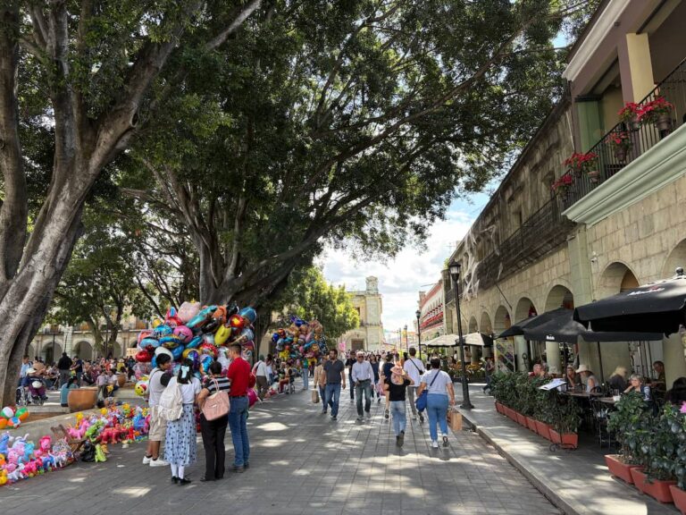
If you’re visiting or living in Puerto Escondido, Huatulco, Mazunte, or anywhere along the Oaxacan coast between May and November, this is worth reading. Not to alarm you — hurricanes affect the coast regularly and life carries on — but because knowing how the system works and where to find reliable information is the difference between being prepared and being caught off guard.
Stay Informed — Where to Get Real-Time Updates
When a storm is approaching, these are the best local sources for current information in Oaxaca. Check these before any national or international news site — they’re faster and more specific to the region.
👉 El Imparcial de Oaxaca — one of the state’s main newspapers, active on Facebook with real-time updates during weather events
👉 Oaxaca Vial y Noticias al Instante — fast local news, good for road conditions and emergency alerts
👉 Noticias Oaxaca Voz e Imagen — reliable local TV news with hurricane and weather coverage
For official government forecasts:
- SMN (Servicio Meteorológico Nacional): smn.conagua.gob.mx
- NOAA (US National Hurricane Center): nhc.noaa.gov — covers the Eastern Pacific in detail
- Protección Civil Oaxaca: the state civil protection agency issues alerts when storms threaten the region
When Does the 2026 Hurricane Season Run?
The season follows the same official dates every year:
- Eastern Pacific (Oaxaca’s coast): May 15 to November 30
- Atlantic Ocean: June 1 to November 30
The most active period for Oaxaca specifically is typically August through October, when sea surface temperatures are at their highest and atmospheric conditions most favor tropical storm development.
Storms can form outside these official dates — particularly early-season Pacific development in May and June — but the official window covers the vast majority of activity.
The 2026 Forecast — Above Average for the Pacific
Mexico’s National Meteorological Service (SMN) issued its 2026 Pacific forecast in April, predicting 18–21 named storms, 9–11 hurricanes, and 4–5 major hurricanes of Category 3 or higher. This is well above the historical average of approximately 15 named storms and 4 major hurricanes per Pacific season.
The driving factor is a strong El Niño expected to develop and strengthen through the peak season months of August to October. El Niño typically supercharges Eastern Pacific hurricane activity while suppressing the Atlantic — meaning if you’re on Mexico’s Pacific coast, this is a season to take more seriously than usual.
The 2026 Eastern Pacific forecast calls for 17–22 named storms, 9–13 hurricanes, and 4–8 major hurricanes, with 6–9 direct impacts to Mexico and Central America.
The Atlantic picture is different: The same El Niño that increases Pacific activity tends to suppress Atlantic storms — the Atlantic is forecast to be a below-average season in 2026. This matters for Oaxaca because the state’s Pacific coast bears the risk, not the Gulf or Caribbean side.
What this means for Oaxaca’s coast: An above-average Pacific season with a strong El Niño doesn’t mean a storm will definitely hit Oaxaca. Most storms track west-northwest and miss the coast. But the elevated probability of major storms means coastal visitors and residents should be more alert than in a typical year.
What’s the First Storm Called in 2026?
The 2026 Eastern Pacific storm names are: Amanda, Boris, Cristina, Douglas, Elida, Fausto, Genevieve, Hernan, Iselle, Julio, Karina, Lowell, Marie, Norbert, Odalys, Polo, Rachel, Simon, Trudy, Vance, Winnie, Xavier, Yolanda, and Zeke.
Storm names are assigned by the World Meteorological Organization (WMO) and rotate on a six-year cycle. Names are retired if a storm causes exceptional damage or loss of life — Hurricane Otis (2023), which devastated Acapulco as a rapid-intensification Category 5, had its name retired.
Mexico’s Hurricane Alert System — How to Read It
Mexico uses the SIAT-CT (Sistema de Alerta Temprana para Ciclones Tropicales) — a five-color alert system managed by Protección Civil. Understanding the colors tells you exactly how serious a situation is:
| Color | Meaning | What to do |
|---|---|---|
| Green | No immediate threat | Monitor forecasts normally |
| Blue | Tropical disturbance forming, 72+ hours away | Stay informed |
| Yellow | Storm possible within 72 hours | Review preparations |
| Orange | Storm likely within 48 hours | Prepare to evacuate if in risk zone |
| Red | Storm imminent within 24 hours | Evacuate immediately if instructed |
When Protección Civil Oaxaca issues an orange or red alert for coastal municipalities, evacuation centers (albergues) are opened. These are typically schools and community centers in elevated, inland locations.
What Causes Hurricanes on Oaxaca’s Coast
The Eastern Pacific off Oaxaca is one of the world’s most productive hurricane-generating regions, and the geography explains why.
Starting in May, sea surface temperatures in the Pacific rise above the 26°C threshold needed for tropical storm development. The Gulf of Tehuantepec — the bay that forms the southern coast of Oaxaca and Chiapas — is particularly warm and creates favorable conditions for storm intensification.
The combination of warm water, reduced wind shear during El Niño years, and atmospheric instability from the Inter-Tropical Convergence Zone (where northern and southern hemisphere trade winds meet) creates the engine for tropical development.
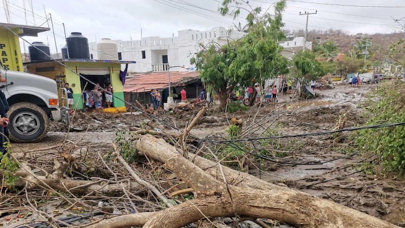
The rapid intensification problem: Hurricane Otis in October 2023 was the starkest recent example of what makes Pacific storms particularly dangerous for this coast. It went from tropical storm to Category 5 in under 24 hours — faster than almost any storm in recorded history — and struck Acapulco with devastating force. Rapid intensification events like this are more common in the Eastern Pacific than the Atlantic, and the 2026 forecast’s elevated major hurricane count reflects that risk.
How Hurricanes Affect Oaxaca — City vs Coast
Oaxaca City (1,550 meters elevation, inland) is not at hurricane risk in the direct sense — no storm makes landfall in the mountains. What the city does experience during major coastal storms is heavy rainfall from the outer bands, occasionally leading to flooding in low-lying neighborhoods and road closures on mountain routes. The new highway to Puerto Escondido may be temporarily closed during significant coastal storms.
The Pacific coast — Puerto Escondido, Huatulco, Mazunte, Zipolite, Pinotepa Nacional — is where the real risk lies. The main hazards are:
- Storm surge — coastal flooding from elevated ocean levels pushed onshore by the storm
- Destructive winds — sustained hurricane-force winds and gusts
- Extreme rainfall — flooding and landslides in coastal and mountain areas
- Dangerous surf — significant wave activity arrives days before a storm makes landfall, making beaches hazardous well in advance
If You’re on the Coast When a Storm is Coming
The most important thing: leave early.
The roads between the coast and Oaxaca City — even the new highway — become congested and occasionally impassable during evacuations. Waiting until an orange or red alert is issued means you’re leaving at the same time as everyone else.
Practical steps:
- Monitor the SMN and NOAA forecasts daily during August–October when you’re on the coast. Storms can develop and track toward the coast within 72–96 hours.
- Know where your nearest albergue (evacuation shelter) is. In Puerto Escondido, shelters are typically designated schools in elevated areas away from the beach. Ask your accommodation host when you arrive.
- Leave before you’re told to. If a storm is forecast to track toward your location and you have the option to travel inland, don’t wait for the red alert.
- Bring cash. ATMs run out quickly during evacuations and card systems may go down.
- Don’t go near the beach. Dangerous surf and storm surge hazards arrive before the wind. A beach that looks dramatic from a distance can be lethal up close.
- If you stay: move to an elevated, solid building away from the coast. Stay away from windows. Have water, food, and a charged phone.
Hurricane Season and Visiting the Oaxacan Coast
Knowing the season runs May through November doesn’t mean you can’t visit the coast during those months — the vast majority of the season passes without any storm directly affecting Oaxaca.
What it does mean:
- September and October are the highest risk months for direct storm impacts. Not impossible to visit, but worth factoring into your planning.
- Travel insurance matters more during hurricane season — look for policies that cover trip interruption and evacuation.
- June and July are lower-risk months despite being in the season — early season storms tend to track west of Oaxaca.
- Surfers note: hurricane swells generate the most powerful waves at Zicatela and the surrounding breaks. The period before a distant storm makes for extraordinary surf — but the same energy that creates good waves makes swimming extremely dangerous.
👉 When to Visit Oaxaca: The Honest Month-by-Month Guide
Historical Storms That Have Affected Oaxaca
Hurricane Pauline (1997) — the most destructive storm to directly hit Oaxaca’s coast in recent memory. Made landfall near Puerto Escondido as a Category 4, causing widespread destruction and significant loss of life. A benchmark event in local memory.
Hurricane Carlotta (2012) — struck near Puerto Escondido as a Category 2, causing damage but no major casualties due to effective early evacuation.
Hurricane Otis (2023) — did not directly hit Oaxaca but devastated neighboring Acapulco as a Category 5. The rapid intensification event was a watershed moment for Pacific coast awareness throughout the region.
These events are reminders that coastal Oaxaca is genuinely vulnerable to major storms — and that preparation and early departure are the most effective responses.
FAQ
Does Oaxaca City get hit by hurricanes? No — Oaxaca City is inland at 1,550 meters elevation and not at risk of direct hurricane impact. The city may experience heavy rainfall and flooding from outer storm bands, but not hurricane-force winds or storm surge.
Which part of Oaxaca is most at risk? The Pacific coast — Puerto Escondido, Huatulco, and the municipalities along the Gulf of Tehuantepec — faces the greatest risk from Eastern Pacific storms.
When is the most dangerous period? August through October, with September and October historically the peak months for major storm activity on Oaxaca’s coast.
What should I do if a hurricane is heading toward Puerto Escondido? Leave early — before the orange alert if possible. Head to Oaxaca City or further inland. Don’t wait for the last minute; roads become congested and may close.
Is it safe to visit the Oaxacan coast during hurricane season? For most of the season, yes. Most storms miss the coast entirely. September and October carry the highest direct risk. Travel insurance and daily monitoring of forecasts are sensible precautions during those months.
Also worth reading: [Is Oaxaca Safe? Honest 2026 Guide] and [Earthquakes Are a Part of Life in Oaxaca]
📍 Discover Oaxaca One Bite at a Time
Download my personal Street Food Map of Oaxaca City – save hours of research and reading trying to find the best street food stalls. From memelas and tlayudas to late-night tacos – these are my 20+ go-to street eats.
- 🎯 Perfect for first-timers & seasoned travelers
- 📍 Instant Google Maps download — just $3.99